
The Parishes of Jamaica Explained: From 7 to 22 to 14, and Now Portmore Makes 15
If you have spent any time in Jamaica, you have heard people anchor themselves to a parish. Someone is from Clarendon, or down in St Elizabeth, or born and raised in St James. The parish is the unit Jamaicans use to say where they belong, the way an American says they are from Ohio or a Canadian says they are from Manitoba. Parishes are the island’s states, its provinces, the oldest layer of local government on the map.
What most people do not realize is that the map has been redrawn many times. Jamaica did not start with fourteen parishes. It started with none, grew to seven, climbed to a peak of twenty-two, and was then cut back down. The fourteen everyone learns in school are the survivors of a consolidation that happened more than a century and a half ago. And as of 2025, that settled number of fourteen is being challenged for the first time since the Victorian era, because Portmore has been legislated as a fifteenth.
This is the full story of how the parishes came to be: where the lines came from, why eight of them vanished, and what the map looks like today.
Before there were parishes
When an English force took Jamaica from Spain in 1655, there were no parishes at all. The Spanish had run the island for a century and a half with a single inland capital, Santiago de la Vega, the town the English would later rename Spanish Town. Outside that centre there was no formal grid of districts.
The English did not impose one overnight. The first attempt at dividing the island came in 1662, and it was practical rather than ceremonial. To carry out a census, officials split Jamaica into ten districts with names like Port Morant, Morant, Yallahs and the Liguanea plain. These were counting units, not governing ones, and they did not last.
The parish itself came from England. Back home, the parish was the basic building block of local administration, tied to the Church of England and to the running of ordinary civic life. Transplanting it to Jamaica gave the young colony a familiar way to organize courts, taxes, churches and record-keeping. In 1664, under Governor Sir Thomas Modyford, the island was divided by law into its first parishes. There were seven of them: St Catherine, Clarendon, St Thomas, St John, Port Royal, St David, and Liguanea, the parish that would soon be renamed St Andrew.

Seven becomes fifteen becomes twenty-two
Once the framework existed, it spread as settlement spread. As planters pushed into new land, the larger parishes were carved up to make government reachable for the people living far from a parish seat.
By about 1675, eight more parishes had been added: Vere, which split off from Clarendon in 1673, along with St George, St Thomas in the Vale, St Dorothy, St Ann, St Elizabeth, St James and St Mary. In 1677 an Act for Regulating the Parishes fixed the boundaries of each one, giving the system its first real legal shape.
The growth continued for more than a century, almost always driven by the same complaint. People on the edges of a big parish were tired of travelling long distances to pay taxes, settle legal matters or attend to official business, so they petitioned to be split off into a new parish closer to home. Kingston was carved out of St Andrew after the 1692 earthquake destroyed Port Royal. Westmoreland was separated from St Elizabeth in 1703. Portland was assembled in 1723 from St George and a slice of St Thomas. Hanover was taken out of Westmoreland the same year. Trelawny was cut from St James in 1770. Manchester was assembled in 1814 from parts of Clarendon, Vere and St Elizabeth.
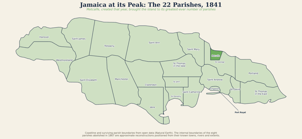
The last parish ever created was Metcalfe, formed in 1841 out of portions of St Mary and St George. With Metcalfe, the count reached its high-water mark: twenty-two parishes.
The great consolidation of 1867
Twenty-two parishes turned out to be too many for a small island to pay for. Each one carried the cost of its own courthouse, jail, vestry and parish officers, and many of the smaller parishes were thinly populated and barely solvent.
The push to simplify came in the wake of a crisis. In 1865, the Morant Bay Rebellion in St Thomas in the East shook the colonial government to its core. In its aftermath the old House of Assembly was dissolved and Jamaica became a Crown Colony governed more directly from Britain. The new governor, Sir John Peter Grant, arrived in 1866 with a mandate to reform how the island was run, and the parish map was one of the first things he overhauled.
Through Law 20 of 1867, A Law to Reduce the Number of Parishes, twenty-two were merged down to fourteen, effective the first of May, 1867. Eight parishes were erased from the map, their land folded into neighbours. That fourteen-parish map is the one Jamaica still uses today, carried unchanged through Independence in 1962 and right up to the present.

The three counties
There is one more layer worth knowing, because it is how the parishes are traditionally grouped. Jamaica is divided into three counties: Cornwall in the west, Middlesex in the middle, and Surrey in the east.
The counties were established in 1758, well before the parish map settled into its final form. Their purpose was to make it easier to hold courts on the English county model. They were named after English counties, and the logic was tidy. Cornwall took the name of England’s westernmost county because it sat at Jamaica’s western end. Middlesex was named for sitting across the island’s middle third. Surrey was named for the English county that contains Kingston upon Thames, since Kingston was its county town.
Today the counties have no administrative function. No taxes are collected by them and no officials are elected to them. But they survive as a way of organizing the island, and the fourteen parishes still sort neatly into the three. Cornwall holds Hanover, St Elizabeth, St James, Trelawny and Westmoreland. Middlesex holds Clarendon, Manchester, St Ann, St Catherine and St Mary. Surrey holds Kingston, Portland, St Andrew and St Thomas.
The eight parishes that no longer exist
The most surprising part of the whole story is the parishes that disappeared. Eight of them were dissolved in 1867 and absorbed into the fourteen that remain. Their names linger in district names, churches and old maps, and many Jamaicans still carry them without knowing they were once parishes in their own right.
Here is where each one went.
Port Royal was the wickedest city in the world before the 1692 earthquake dropped most of it into the sea. As a parish it was divided in 1867 between Kingston and St Andrew, and the old town is now part of the Kingston parish.
St George sat on the north coast and was split between St Mary and Portland.
St David lay east of Kingston and was folded into St Thomas. To absorb it, St Thomas in the East simply dropped the “in the East” and became plain St Thomas.
Metcalfe, the youngest parish of them all, lasted only twenty-six years before it was reabsorbed into St Mary in 1867.
St Dorothy was merged into St Catherine. The name survives in places like St Dorothy’s Anglican Church near Old Harbour.
St John was also merged into St Catherine.
St Thomas in the Vale was the third parish swallowed by St Catherine, which is part of why St Catherine grew into one of the largest parishes on the island.
Vere, a flat sugar parish on the south coast, was joined to Clarendon. The poet and folklorist Olive Senior was born in what was once Vere.
Three of those eight, St Dorothy, St John and St Thomas in the Vale, all went into St Catherine at once, which is the single biggest reason that parish ballooned in size. Clarendon absorbed Vere. St Thomas absorbed St David. The geography of modern Jamaica is, in large part, the geography of these mergers.
The fourteen parishes today
What follows is a tour of the fourteen parishes as they stand now, grouped by county, with how each one came to be, where its name comes from, and what gives it its character. Kingston, the capital and the heartbeat of the nation, comes first.
Surrey County
Kingston
Kingston is the smallest parish in Jamaica and, until quite recently in the island’s history, it did not exist at all.
Before 1692, the action on this part of the coast was at Port Royal, the buccaneer port at the mouth of the harbour that grew rich on plunder and earned its reputation as the wickedest city in the world. Then, on a June morning in 1692, a massive earthquake and the waves that followed destroyed roughly two-thirds of Port Royal and killed around three thousand people. Survivors fled across the water to the Liguanea plain, where many more died of exposure and disease.
Two weeks after the disaster, the government bought two hundred acres of land known as Colonel Barry’s Hog Crawle for the purpose of building a new town. That town was Kingston, and a surveyor named John Goffe drew up its grid. For a while Port Royal clawed back its residents, until a catastrophic fire in 1703 finished off what the earthquake had spared and sent people back to Kingston for good. Soon after, Kingston was declared the island’s chief port of trade, and in 1713 it was confirmed by law as a distinct parish.
For nearly two centuries the colonial capital remained at Spanish Town, but Kingston’s harbour, its commercial weight and its growing population made it the natural centre of the country. After more than a hundred years of lobbying by Kingston merchants, the capital was formally moved to Kingston in 1872. The city survived another devastating earthquake in 1907, which levelled much of downtown and reshaped the building codes that followed.
The thing that confuses almost everyone about Kingston is its relationship with St Andrew. The two parishes have grown into each other so completely that they are administered together as the Kingston and St Andrew Corporation, formed in 1923. When people say “Kingston,” they usually mean the whole sprawling urban area, most of which is actually in St Andrew. The parish of Kingston proper is a small wedge along the harbour. It remains the smallest parish by land area and the densest, the hub of the nation packed into the least space.
St Andrew
St Andrew was one of the original parishes of 1664, and its older name still echoes around the city. It was first called Liguanea, from one of the few surviving Taino words on the island, thought to come from the word for iguana. The plain that Kingston sits on is still called Liguanea today.
St Andrew wraps around Kingston on three sides and climbs from sea level all the way up into the Blue Mountains, sharing borders with St Thomas, Portland, St Mary and St Catherine. Its capital is Half Way Tree, named for a great cotton tree that once stood at a junction where travellers heading into Kingston from the western parishes would stop to rest. The clock tower that stands there now was raised as a memorial to King Edward VII.
This is the parish of Jamaica’s commercial and political uptown. New Kingston, the cluster of office towers and hotels, sits in St Andrew, as do King’s House and Jamaica House, the official residences of the Governor-General and the seat of the Prime Minister’s office. Today St Andrew is the most populous parish in the country.
Portland
Portland occupies the lush, rain-soaked northeast corner of the island, and it is one of the parishes assembled rather than inherited. It was created in 1723 from the old parish of St George and a portion of St Thomas, and it was named after the Duke of Portland, who was governor at the time. In 1867 it absorbed more of St George’s old territory.
The parish lies directly in the path of the trade winds, which makes it one of the wettest parts of Jamaica and gives it its famous deep-green landscape of mountains, rivers and waterfalls. Its capital, Port Antonio, holds a special place in the island’s story as the birthplace of Jamaican tourism. When the banana trade took off in the late nineteenth century under the American captain Lorenzo Dow Baker, his banana boats began carrying curious visitors back to Jamaica, and the sleepy port became the island’s first tourist town.
Portland is also Maroon country. The Windward Maroons held the Blue and John Crow Mountains here, and the parish is the home of Moore Town and of Nanny of the Maroons, Jamaica’s only national heroine. The Blue and John Crow Mountains, part of which lies in Portland, became the island’s first World Heritage Site.
St Thomas
St Thomas sits in the southeast, running from the peaks of the Blue Mountains down to the Caribbean. For most of its history it was called St Thomas in the East, a name designed to tell it apart from the long-gone parish of St Thomas in the Vale. When that second St Thomas was dissolved into St Catherine in 1867, the eastern one absorbed the old parish of St David and simply became St Thomas.
Its capital is Morant Bay, and the parish is bound up with one of the most important events in Jamaican history. In 1865 the Morant Bay Rebellion, led by the Baptist deacon Paul Bogle, erupted here. Its violent suppression and its political fallout brought down the old Assembly and turned Jamaica into a Crown Colony, the very chain of events that led to the 1867 reduction of the parishes. Paul Bogle and George William Gordon, both connected to these events, are national heroes today. The parish is also home to the Bath mineral springs, discovered in the late seventeenth century and long valued for their healing waters.
Middlesex County
St Catherine
St Catherine is one of the seven original parishes of 1664, and it was named for Catherine of Braganza, the Portuguese queen of King Charles II. In its early centuries it was far smaller than it is now. It grew into one of the largest parishes on the island in 1867, when it swallowed three dissolved parishes at once: St Dorothy, St John and St Thomas in the Vale.
Its capital, Spanish Town, is one of the most historic places in the Caribbean. Founded by the Spanish as Santiago de la Vega, it served as the capital of Jamaica under both Spain and England, and it held that role for centuries until the seat of government moved to Kingston in 1872. Its old square, cathedral and the cast-iron Rodney Memorial still mark its former importance.
St Catherine also holds Sligoville, recognized as the first free village established in Jamaica after emancipation, and Portmore, the vast dormitory city that has become the centre of the parish’s modern story. Today St Catherine is the second most populous parish, and as the home of Portmore it is at the heart of the question of whether Jamaica is about to have a fifteenth parish.
Clarendon
Clarendon spreads across the south-central plains, roughly halfway between the eastern and western ends of the island. It takes its name from Edward Hyde, the first Earl of Clarendon, a leading minister in the government of Charles II. In 1867 it absorbed the old sugar parish of Vere and part of St Dorothy, growing into one of the island’s largest parishes.
Its character is set by its geography: a wide, flat plain ideal for large-scale agriculture, framed by mountains to the east and west. The Rio Minho, the island’s longest river, runs through it. Its capital is May Pen, which grew from a couple of inns on the riverbank into a busy town and became the parish capital in the late 1930s, replacing the older hill town of Chapelton. Clarendon built its economy first on sugar and later on bauxite, and it hosts Denbigh, the country’s largest agricultural show, every August.
Manchester
Manchester is one of the youngest parishes and one of the few created entirely from the interior rather than the coast. At the start of the nineteenth century, coffee growers in the cool hill districts where Clarendon, Vere and St Elizabeth met found themselves too far from any parish seat to manage their affairs. They petitioned for their own parish, and in 1814 Manchester was formed from pieces of all three. It was named after the Duke of Manchester, then the governor, and its capital, Mandeville, was named after his son.
Sitting high on a mountain plateau, Mandeville enjoys a cool climate that made it a favourite of British settlers, and the town has long been described as the most English of Jamaican towns. The parish ran on coffee and cattle until bauxite was discovered here in the 1940s, which reshaped Mandeville into one of the largest and most prosperous inland towns in the country.
St Ann
St Ann is the largest parish in Jamaica by land area, and it is known across the island as the Garden Parish for its lush hills and red, bauxite-rich soil. Its history reaches back to the very beginning of the European presence in Jamaica. It was here, at what is now St Ann’s Bay, that Christopher Columbus first landed on the island in 1494. A few kilometres away, the Spanish built Sevilla la Nueva, or New Seville, the island’s first Spanish capital and one of the earliest European settlements in the Americas.
The parish was named Santa Ana by the Spanish, later anglicized to St Ann, and its capital is St Ann’s Bay. In the modern era the parish became one of the twin engines of the Jamaican economy, with bauxite mining inland and tourism on the coast at Ocho Rios. St Ann is also the birthplace of national hero Marcus Garvey, born in St Ann’s Bay in 1887.
St Mary
St Mary runs along the northeast coast and is among the older parishes, beginning as a precinct around 1662 and confirmed as a parish later in the century. Its name is usually traced to Port Maria, the coastal town the Spanish called Puerto Santa Maria. In 1867 it absorbed the dissolved parish of Metcalfe and part of St George, which is how it reached its present shape.
Its capital is Port Maria, one of the oldest towns on the island. The parish was a centre of the early sugar economy and later a major banana-growing district. It carries a heavy chapter of resistance history as the cradle of Tacky’s Rebellion of 1760, one of the most serious uprisings of the era. In a lighter vein, St Mary is also where the author Ian Fleming built his home, GoldenEye, at Oracabessa, and wrote the James Bond novels. The island’s smaller north-coast airport is named in his honour.
Cornwall County
St James
St James belongs to the second wave of parishes, named in the 1670s after James, Duke of York, who would later become King James II. When it was first laid out it was far larger than it is now, taking in what would later become the separate parishes of Trelawny and Hanover.
Its capital is Montego Bay, which grew from a sparsely settled north-coast outpost into the second largest town on the island and, in 1980, into Jamaica’s official second city. The parish carries one of the defining events of the road to emancipation: the Christmas Rebellion of 1831, also called the Baptist War, led by the national hero Samuel Sharpe. Today St James is the heart of Jamaica’s tourism industry, with Montego Bay contributing a large share of the country’s tourism earnings, and it is home to the famous great house at Rose Hall.
Trelawny
Trelawny was cut from St James in 1770, after settlers in the western reaches of that large parish complained, as so many Jamaicans did, that the journey to the parish seat at Montego Bay was simply too far. The new parish was named after Sir William Trelawny, the governor of the day.
Its first capital was Martha Brae, but the role soon passed to Falmouth, a port named to honour Trelawny’s birthplace in Cornwall, England. In its sugar-era heyday Falmouth was a prosperous Georgian town, and so much of its architecture survives that its historic district is a protected national monument, now anchored by a modern cruise-ship pier. Trelawny was once the parish with the most sugar estates of any in Jamaica, and today it is the country’s main producer of yam. Much of the wild Cockpit Country lies within its borders, and it is the birthplace of the fastest man in history, Usain Bolt, from the small community of Sherwood Content.
Westmoreland
Westmoreland was separated from St Elizabeth in 1703, and its name almost certainly comes from its position as the most westerly land on the island. Its capital is Savanna-la-Mar, a Spanish name meaning “plain by the sea,” developed from around 1730 as the port through which the parish shipped its sugar.
The parish holds a pivotal place in modern Jamaican history. In 1938, labour riots at the Frome sugar estate became a turning point, helping to spark the trade union movement and setting the island on the road toward universal adult suffrage and, eventually, self-government. Westmoreland is also where you will find Negril, the parish’s tourism engine and one of the most famous resort areas in the country. Tucked into the parish as well is Seaford Town, settled by German immigrants in the nineteenth century, whose descendants still live there.
Hanover
Hanover is the smallest parish in Jamaica by land area. It was taken out of Westmoreland in 1723, reportedly because residents were tired of travelling as far as fifty miles to pay their taxes, the same recurring grievance that created so many of the island’s parishes. It was named for the House of Hanover, the German royal line of the reigning King George I.
Its capital is Lucea, set on one of the island’s safest natural harbours and known for a distinctive clock that, by local legend, was meant for somewhere else entirely before the people of Lucea decided to keep it. The parish gave its name to the Lucea yam and built its early economy on sugar around the port. Hanover often gets overshadowed by the tourist glow of nearby Montego Bay, but it shares something important with its southern neighbour: the northern end of the Negril strip crosses into Hanover.
St Elizabeth
St Elizabeth is among the oldest parishes, in existence by the 1670s, and it was named in honour of Lady Elizabeth Modyford, the wife of Governor Sir Thomas Modyford. In its early days it was enormous, covering most of western Jamaica. It gave up the land that became Westmoreland in 1703 and the land that became Manchester in 1814, and even after losing both it remains one of the largest parishes on the island.
Its capital, Black River, is one of the oldest towns in Jamaica and was reportedly the first place on the island to get electricity, in the 1890s. The parish is famous as the breadbasket of Jamaica, its broad plains and savannahs supplying a large share of the country’s vegetables and produce. It is home to the Accompong Maroons, who hold one of the most enduring free communities on the island, and the Black River itself, the longest river in Jamaica, supports a wetland that shelters the island’s crocodiles.
The fifteenth parish: Portmore
For more than a century and a half, fourteen was the settled answer to how many parishes Jamaica has. That is now changing.
Portmore sits on the southeastern coast of St Catherine, about 24 kilometres from Kingston, on land that for most of its history was considered too dry for sugar and was left to grazing pens. One of those pens, Portmore Pen, gave the area its name, which traces back to the Earl of Portmore, a Scottish title the landowning Dawkins family had married into. The modern city is a recent creation. When Kingston ran out of flat land to build on in the 1950s and 1960s, Portmore became its overflow, its marshy lowlands diked against the Rio Cobre and linked to the capital by a causeway. Housing schemes spread across it from 1969 onward, and the population climbed from fewer than two thousand people to more than two hundred thousand, making Portmore the largest residential area in the Caribbean.
It has long been unusual in another way too: a community with its own municipal council, granted municipal status in 2003, operating somewhat apart from the rest of St Catherine’s local government. For years there has been a push to recognize that scale by making Portmore a parish in its own right, the way Kingston was once carved out of St Andrew.
In 2025 that push became law. The Counties and Parishes (Amendment) Act passed the House of Representatives on the eleventh of February and the Senate on the twenty-eighth of February, designating Portmore as Jamaica’s fifteenth parish. The government described it as the first time in post-colonial Jamaica that a new parish was being created, the first change to the map since 1867.
The story is not finished, though. The move was challenged on constitutional grounds, because Jamaica’s constitution does not allow a constituency boundary to cross a parish boundary, and the new parish lines complicate several constituencies. The Supreme Court ruled that the Act would only come into full operation once the required boundary review is completed, and that review is still under way. As of mid-2026, the Electoral Commission of Jamaica had only recently begun the consultations needed to redraw the affected boundaries. In other words, Portmore has been legislated as the fifteenth parish, but it is still being formally brought into being.
So the honest answer to “how many parishes does Jamaica have” is now layered. Fourteen have governed the island since 1867. A fifteenth, Portmore, is on the way, working its way through the last constitutional steps. The map that held steady for more than 150 years is being redrawn in real time.
A footnote for Negril: the parish line on the beach
Here is something most visitors to Negril never realize. Negril is not in one parish. It is split across two.
The bulk of Negril, including the West End cliffs and most of the famous seven-mile beach, sits in Westmoreland. But the northern end of the beach crosses into Hanover. The boundary between the two parishes runs along the Negril River, which empties into the sea right at the resort area. Stand on the sand at the right spot and you can walk from one parish into another without any sign telling you so.
The name itself is a small piece of parish history too. Negril comes from the Spanish, who marked the headland at the western tip of the island as Punta Negrilla, a name that survived the centuries to become Negril Point. The Spanish are long gone, the parishes have been drawn and redrawn around it, but the western end of Jamaica still carries the name they left behind.
It is a fitting place to end a story about parishes. The lines on the map can feel permanent, fixed and obvious, until you look closely and see that they have always been moving, and in the case of Negril, that they run quietly through the middle of the beach.
| Parish | Capital | Land area (sq km) | Population (2022) | % of Jamaica |
|---|---|---|---|---|
| Cornwall (west) | ||||
| Hanover | Lucea | 450 | 69,780 | 2.5 |
| St James | Montego Bay | 595 | 188,656 | 6.8 |
| St Elizabeth | Black River | 1,212 | 153,201 | 5.5 |
| Trelawny | Falmouth | 875 | 77,427 | 2.8 |
| Westmoreland | Savanna-la-Mar | 807 | 146,205 | 5.3 |
| Middlesex (central) | ||||
| Clarendon | May Pen | 1,169 | 258,643 | 9.3 |
| Manchester | Mandeville | 830 | 193,694 | 7.0 |
| St Ann | St Ann’s Bay | 1,213 | 175,310 | 6.3 |
| St Catherine | Spanish Town | 1,192 | 542,763 | 19.6 |
| St Mary | Port Maria | 611 | 116,497 | 4.2 |
| Surrey (east) | ||||
| Kingston | Kingston | 22 | 672,904 * | 24.3 * |
| St Andrew | Half Way Tree | 431 | incl. above | incl. above |
| Portland | Port Antonio | 814 | 84,972 | 3.1 |
| St Thomas | Morant Bay | 743 | 94,485 | 3.4 |
| Jamaica total | 10,964 | 2,774,538 | 100 | |
* The 2022 Census counts Kingston and St Andrew as one unit, the Kingston and St Andrew Corporation (KSA), so the figure covers both. They remain two separate parishes, which is how the count reaches 14. Portmore, legislated as a prospective 15th parish, is not yet in force; its land and people are still counted within St Catherine. Population: STATIN 2022 Census. Land areas are standard survey figures and vary slightly between sources.
The southeast corner does the heavy lifting. Kingston and St Andrew together with St Catherine hold about 44 percent of every Jamaican. Add Clarendon next door and you are past half the country, all of it banked around the capital.
Now add the western column. The five parishes of Cornwall, the entire western half of the island, come to roughly 23 percent between them. Westmoreland and Hanover, the two parishes that share Negril, total under 8 percent combined.
In a country where seats and spending follow heads, that arithmetic explains a great deal. Outside Kingston it is hard to be heard without size, and the west has never had the numbers to demand it. The same arithmetic explains the other half of the picture. The crowd is in the east. The space is in the west. You do not need an argument for that. You just add the columns.
Sources: B.W. Higman and B.J. Hudson, Jamaican Place Names (University of the West Indies Press, 2009); The Laws of Jamaica, 1867, No. 20: A Law to Reduce the Number of Parishes; The Counties and Parishes (Amendment) Act, 2025.
For more on Negril real estate and investment trends, read How to Buy Property in Jamaica: The Diaspora Guide and Hotel-to-Condo Conversions in Negril. Browse all Negril businesses at DiscoverNegril.com.